The Sun heats the Earth unevenly: The Sun is the main source of energy for the climate, but it heats the equator far more than the poles. The atmosphere moves to even this out, and that movement shapes the climate of every latitude.
The points to remember
- Latitude is the angle north or south of the equator, measured from the Earth's centre, in degrees.
- The Earth is a sphere and tilted, so sunlight strikes each latitude at a different angle.
- Near the equator the sun is high: its energy falls on a small area, so it is hot.
- Near the poles the same energy is spread over a large area and crosses more air: cold.
- Day length also changes with latitude and season.
- The equator has a surplus of heat, the poles a deficit: moving air carries heat poleward and evens out the extremes.
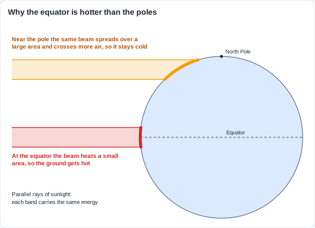
Real example: Singapore, at 1°N, averages about 27 °C in every month. Tromso in Norway, at 70°N, averages about 3 °C over the year and has no sunrise for about seven weeks in winter.
Remember it as: High sun, hot ground; low sun, cold ground.
Free preview
This is the free notes preview
You're reading the free notes. Aimnova Pro unlocks the full study experience — and you can try it with your first topic free to keep:
- FlashcardsLock in vocabulary and key terms with spaced repetition.
- Practice questionsAnswer exam-style questions and get instant AI marking.
- Mock exams & past-paper vaultSit full mocks and see exactly how examiners award marks.
- Personalised study planA daily plan built around your exam date and weak areas.
Uneven heating makes air move up and down. Where air rises, it rains; where air sinks, it is dry. This one idea explains most of the world's rain belts and deserts.
Rising air, sinking air
- Warm air is less dense, so it rises (convection); cool air is denser and sinks.
- Rising air leaves low pressure at the ground.
- As it rises it cools; its water vapour condenses into clouds; once saturated, it rains.
- Sinking air gives high pressure; it warms as it sinks, so clouds evaporate and it is dry.
- Near the equator the sun is overhead and the trade winds meet: the ITCZ, a belt of heavy rain.
Rising air
- Low pressure
- Cools, water vapour condenses
- Clouds and heavy rain
Sinking air
- High pressure
- Warms, clouds evaporate
- Clear skies, dry
Real example: in Singapore, the morning sun heats the ground, warm moist air rises, and tall cumulonimbus clouds build up by the afternoon. It gets about 2,500 mm of rain a year.
Say the whole chain: Rises, cools, condenses, clouds, rain. Each step is a point; 'rising air causes rain' on its own skips them.
Feeling unprepared for exams?
Get a clear study plan, practice with real questions, and know exactly where you stand before exam day. No more guessing.
The tricellular model links the rising and sinking air into three loops in each hemisphere: the Hadley, Ferrel and polar cells.
The three cells
- Hadley cell (0-30°): air rises at the equator, flows poleward high up, sinks at 30°.
- It returns to the equator along the ground as the trade winds.
- Polar cell (60-90°): cold, dense air sinks at the pole and flows to 60° as the polar easterlies.
- At 60° it meets warmer air and rises.
- Ferrel cell (30-60°): turns the opposite way, driven by the other two: westerlies at the surface.
- Together the cells carry heat from the tropics towards the poles.
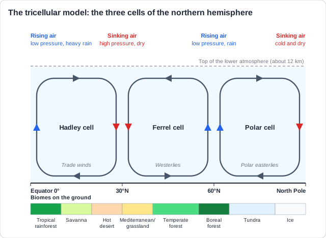
Remember it as: Up at 0, down at 30, up at 60, down at 90.
Real example: in 1492 Columbus sailed south to the Canary Islands to pick up the steady north-east trade winds, the surface flow of the Hadley cell, which carried his ships across the Atlantic.
Annotating the cells: Draw an arrow on every side of every loop: up at 0° and 60°, down at 30° and 90°. The Ferrel cell turns the other way from its neighbours.
The cells decide where it is wet or dry, and the heat they carry decides where it is warm or cold. Rain and temperature decide the soil and which plants grow, and how fast: the biome, its structure and its productivity.
From cells to biomes
- 0-10°: rising air, low pressure, rain all year: tropical rainforest, the highest NPP.
- 10-20°: rain only when the rain belt moves over in summer: savanna.
- About 30°: sinking air, high pressure, very dry: hot deserts with low NPP.
- 40-60°: westerlies bring moisture from the oceans: temperate forest and grassland.
- Near 60°: rising air brings rain and snow: boreal forest.
- Polar: sinking, cold, dry air: tundra and ice, very low NPP.
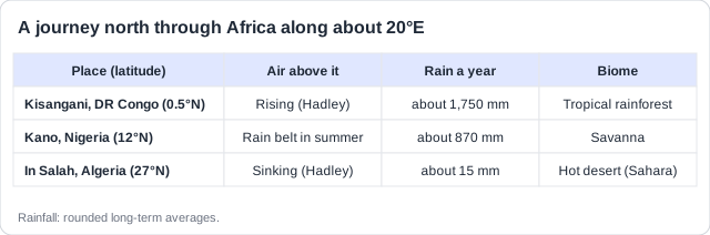
Real example: travel north through Africa along 20°E. At Kisangani, under rising air, the rainforest is tall, layered and very productive. Past Kano the rain lasts only a few months: savanna. At In Salah, under sinking air, the Sahara gets about 15 mm a year and plants are scattered.
Link every biome to the climate: Naming a biome is not enough: say why, with its temperature or precipitation. 'Sinking air at 30° gives high pressure and very little rain, so hot deserts form.'
Memorize terms 3x faster
Smart flashcards show you cards right before you forget them. Perfect for definitions and key concepts.
Like every model, the tricellular model leaves things out. Real rain belts bend around mountains, coasts and seasons, so some biomes sit where the simple model would not put them.
Where the model needs help
- The model is simplified: real winds, land and sea bend the neat belts.
- Prevailing winds bring rain from the sea: temperate rainforest grows on windward coasts and mountains.
- Behind high mountains lies a dry rain shadow: deserts and steppe far from 30°.
- The rain belt moves north and south with the seasons, giving the savanna its wet and dry seasons.
- Altitude and distance from the sea also change temperature and rain.
Real example: the Gobi desert lies at about 43°N, far from the 30° belt. The Himalaya and the Tibetan Plateau block moist air, leaving it in a rain shadow, and it is far from any sea.
Use it as a strength or a limit: In an 'outline the role of the atmosphere' question, prevailing winds and rain shadows each earn a point of their own, beyond the three cells.
How this comes up: Paper 2, Section A: explain how the tricellular model influences the structure of biomes [4].
Tropical rainforest, hot desert and tundra lie in belts at different latitudes.
Explain how the tricellular model of atmospheric circulation influences the distribution of these biomes.
Model answer plan
See the mark-by-mark plan — for / against / judgement, with marking guidance — in study mode.