Designing reserves at Higher Level: Different places from SL: the Maya Biosphere Reserve, Yellowstone, Banff and Nairobi National Park. At HL, weigh who pays for good design, which laws protect a corridor across a border, and whether zoning is fair to local people.
Practise this as you read
- Judge a design from a map: size, shape, habitats, place, links.
- Argue how far design, rather than management, decides success.
Free preview
This is the free notes preview
You're reading the free notes. Aimnova Pro unlocks the full study experience — and you can try it with your first topic free to keep:
- FlashcardsLock in vocabulary and key terms with spaced repetition.
- Practice questionsAnswer exam-style questions and get instant AI marking.
- Mock exams & past-paper vaultSit full mocks and see exactly how examiners award marks.
- Personalised study planA daily plan built around your exam date and weak areas.
Design for the species you want to save: A reserve works only if it gives its target species everything it needs. So the design starts with the species' biology, then asks where the reserve should go.
The points to remember
- Know the target species: how much space it needs, what it eats, where it breeds, whether it migrates.
- Top predators and large animals need the largest areas.
- The reserve must hold a population large enough to breed and keep its genetic diversity.
- Place it where biodiversity is high, especially endemic species found nowhere else.
- ...where the threat is greatest (e.g. fast deforestation) and where it can link to another park.
- ...where few people live, so there is less conflict, and where ecotourism can pay for it.
Remember it as: Space, food, breeding, moving: then place.
Example (HL): jaguars of the Maya forest. A jaguar needs a large territory and plenty of prey such as deer and peccaries, and males travel far to find mates. Only a very large forest holds a jaguar population that can last. That is one reason the Maya Biosphere Reserve in northern Guatemala covers about 21 000 km², a fifth of the country.
Asked why a park was created in a place?: Read the figures for: high or endemic biodiversity, a threat such as deforestation, a link to another park, few villages, and a chance for ecotourism. Two different reasons, two marks.
Feeling unprepared for exams?
Get a clear study plan, practice with real questions, and know exactly where you stand before exam day. No more guessing.
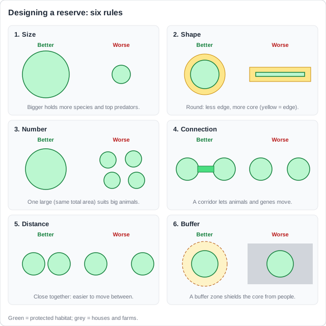
Once the species is known, size and shape decide how much good habitat a reserve really gives.
The points to remember
- Bigger is better: more habitats, more species, larger populations, room for top predators.
- Edge effects: near a boundary it is lighter, windier, hotter and drier; invasive species, predators and people get in.
- The edge is poorer habitat, so what counts is the core left inside.
- A round or square shape has the lowest edge-to-area ratio; a long, thin reserve is mostly edge.
- One large or several small? One large suits big animals; several small spread the risk of fire or disease.
Example (HL): Yellowstone and beyond. Yellowstone National Park covers about 9000 km², yet its grizzly bears and wolves range far outside it, and some are killed there. Scientists showed it is too small on its own for these animals, which led to the Yellowstone to Yukon plan to link parks along 3200 km of the Rocky Mountains.
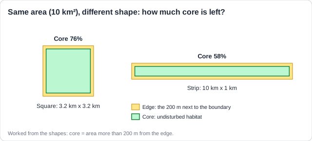
Edge-to-area: say what it does: Not just 'long and thin is bad'. Say that a long, thin shape has a high edge-to-area ratio, so edge effects (and people, poachers, invasives) reach more of the reserve.
Reserves cut off by farms, towns and roads become islands. Wildlife corridors join them into a network.
Why corridors help
- Gene flow: animals from different reserves meet and breed, so less inbreeding.
- Migration and seasonal movement; animals can recolonise a reserve that lost its population.
- Species can move as the climate shifts their range.
- Green bridges and underpasses cut road deaths.
- Several smaller reserves can work together like one large one.

Why corridors are difficult
- Less protection than a reserve; poaching along narrow strips.
- Roads cross them: road deaths; too narrow for territorial animals, and mostly edge.
- They can spread disease, invasive species and predators between reserves.
- Costly land; conflict with farmers; hard to decide where to put them.
- Across borders they need international agreement, which is hard to reach.
Example (HL): Banff National Park, Canada. The Trans-Canada Highway cuts through the park. Six wildlife overpasses and 38 underpasses, with fencing that steers animals to them, have cut collisions between vehicles and large animals by over 80%. Bears, wolves and elk use them.
Species that cross borders: A migrating species needs protection in every country on its route. Agreements between countries are hard to reach, birds may be hunted where they are not protected, routes vary, and storms and predators strike on the way.
Memorize terms 3x faster
Smart flashcards show you cards right before you forget them. Perfect for definitions and key concepts.
Pristine core, buffer, transition: A UNESCO biosphere reserve is zoned in rings: a pristine core, a buffer zone around it, and an outer transition zone that is sustainably managed.
The points to remember
- Core: strictly protected and pristine; only research and monitoring.
- Buffer zone: low-impact uses (research, education, ecotourism, some traditional harvesting); it shields the core from edge effects.
- Transition zone: people live, farm, fish and work, but sustainably.
- Zoning joins conservation with local people's needs, so they support the reserve.
- It lets a park allow harvesting (trapping, fishing, grass cutting) away from the core.
Remember it as: Keep out, tread lightly, live well.
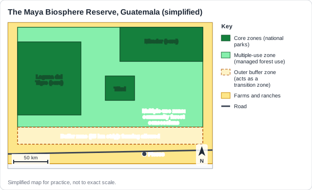
Example (HL): the Maya Biosphere Reserve, Guatemala (UNESCO, 1990). Its core zones are national parks such as Tikal. A large multiple-use zone, which works as a buffer, is managed by local communities that harvest certified timber and palm leaves. A 15 km strip on the southern edge, where farming is allowed, works as the transition zone. It shelters jaguars, scarlet macaws and Baird's tapirs.
Why allow hunting or trapping in a park?: In Canada's Algonquin Provincial Park, First Nations people may trap beavers. The reasons: their right to keep their culture; beavers are common (least concern) and recover quickly; trapping is small scale and only in some zones; it also cuts beaver damage.
People affect every reserve, inside it and from the land around it. Management tries to keep the benefits and cut the harm.
The points to remember
- Human impacts: poaching, tourists who disturb and trample, invasive species, pollution, water taken from rivers.
- From outside: urban sprawl, farms, roads and new power plants fragment and pollute habitat.
- Management: rangers and patrols, zoning with permits and quotas, no-take zones.
- Management: removing invasive species, restoring habitat, monitoring species and water.
- Management: tourist fees that pay for protection, and involving local people so they benefit.
Example (HL): managing the Maya reserve. In the multiple-use zone, community forest concessions harvest certified timber, and forest loss there has been close to zero. In the western core parks, such as Laguna del Tigre, illegal cattle ranching, fires and drug trafficking cleared large areas. The same reserve shows that local benefit protects forest better than a line on a map.
Management that helps
- Patrols cut poaching.
- Tourist fees fund rangers.
- Removing invasives helps natives.
- No-take zones rebuild fish stocks.
- Local people share the benefits.
Management that can hinder
- Herbicides on invasives harm natives.
- Clearing can cause soil erosion.
- Tourists trample and disturb.
- No-take zones cost fishers income.
- The park may be too small a share of the region.
Which measure worked best? Look at the population after each measure began, and at the records of deaths. Amur tigers in Russia rose from about 50 in 1940 to about 500 by 2009: the rise was fastest after the trade ban, while poaching went on after the hunting ban. So the trade ban looks most successful and the hunting ban alone least. Give a strength, a weakness and this kind of conclusion.
Help or hinder? Take both sides: A Discuss [6] on management gives at most four points a side, then a judgement. Take points from the whole case: the park and the city or farms around it.
Know your predicted grade
Take timed mock exams and get detailed feedback on every answer. See exactly where you're losing marks.
Papers give a map of a real park and ask you to judge its design: its size, shape and position.
The points to remember
- Size: large enough for its species?
- Shape: round and compact, or long and thin with a high edge-to-area ratio?
- Habitats: does it include many ecosystems and elevations, breeding and nursery grounds?
- Position: near cities, airports, roads or farms? Any buffer zone?
- Connection: in one piece or fragmented? Any corridors to other parks?
Remember it as: Size, shape, habitats, place, links.
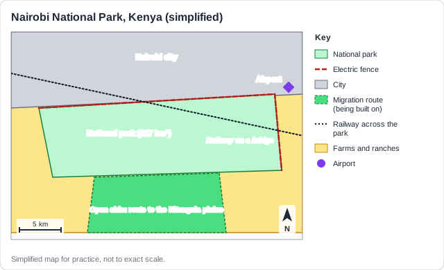
Example (HL): Nairobi National Park, Kenya. Advantages: lions, rhinos and giraffes within 10 km of a capital city, and an open southern side that lets wildebeest and zebra migrate. Disadvantages: only 117 km², a city and fence on three sides, a railway built across it, and its migration route south being fenced and built on, so it risks becoming an island.
Design is not management: In a design question, points about tourists, trail erosion or rangers do not count. Also, 'close to the city' alone is not enough: say what it causes (poaching, pollution, fire, road deaths).
Describing a pattern from the map. Use the key and give the trend: 'most parks lie above 1000 m, in the mountains'. If you say there is no pattern, give the evidence, such as a park in a lowland wetland.
How this comes up: Paper 1: identify a design advantage and disadvantage [2], evaluate a design [4], discuss management [6]. Paper 2 Section B (c): to what extent do design and management decide success [9].
Protected areas range from Nairobi National Park, on the edge of a capital city, to the Maya Biosphere Reserve, a fifth of Guatemala.
With reference to named examples, to what extent does the design of protected areas determine whether they succeed in conserving biodiversity?
Model answer plan
See the mark-by-mark plan — for / against / judgement, with marking guidance — in study mode.