Three climate patterns at Higher Level: An HL-only page. Singapore and Darwin are both hot, yet one has rainforest and the other dry grassland with trees. Dublin and Winnipeg lie at almost the same latitude, yet one has mild winters and the other minus 16°C. This page sorts every climate into three patterns and explains why each has its own biomes.
Practise this as you read
- Identify a climate type from a map or a climate graph.
- Explain why two places have different climate types and biomes.
Free preview
This is the free notes preview
You're reading the free notes. Aimnova Pro unlocks the full study experience — and you can try it with your first topic free to keep:
- FlashcardsLock in vocabulary and key terms with spaced repetition.
- Practice questionsAnswer exam-style questions and get instant AI marking.
- Mock exams & past-paper vaultSit full mocks and see exactly how examiners award marks.
- Personalised study planA daily plan built around your exam date and weak areas.
Three patterns, one main cause: The world's climates fall into three general patterns, tropical, temperate and polar, set mainly by latitude, which decides the insolation a place gets. Each pattern has its own biomes.
The points to remember
- Climates fall into three patterns: tropical, temperate and polar.
- The main reason is latitude: how high the sun climbs, so how much insolation a place gets.
- Tropical: between about 23.5°N and 23.5°S, the sun is high all year: warm in every month.
- Temperate: the mid-latitudes, the sun's height changes with the seasons: warm summers, cool winters.
- Polar: beyond about 66.5°, the sun is low or absent for months: cold all year.
- Each pattern splits into types, and each type has its own biomes.
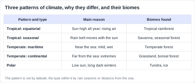
Remember it as: Hot all year, seasons, cold all year: tropical, temperate, polar.
Real example: travel north along 100°W, from the Pacific coast of Mexico to the Arctic coast of Canada. You pass from tropical dry forest near Acapulco, through the prairies of the Dakotas and Manitoba, into the boreal forest and finally the tundra of Nunavut: all three patterns in one journey.
Practice with exam-style questions
Answer exam-style questions and get AI feedback that shows you exactly what examiners want to see in a full-marks response.
All tropical climates are hot. What splits them is rain: all year, or only in one season. The ITCZ decides which.
Tropical: equatorial and seasonal
- Equatorial: near the equator, hot (about 27°C) and wet in every month.
- Why: the ITCZ sits over it all year; heated air rises, cools and gives rain almost daily.
- Biome: tropical rainforest.
- Seasonal: further from the equator, hot all year but with a wet season and a dry season.
- Why: the rain belt moves north and south with the overhead sun; when it leaves, sinking air brings drought.
- Biomes: savanna and tropical seasonal (dry) forest.
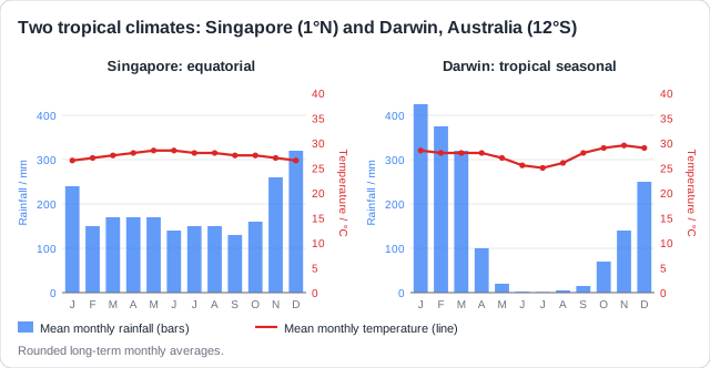
Singapore (1°N): equatorial
- About 27°C in every month
- About 2,200 mm of rain, spread over the year
- The ITCZ is overhead all year
- Natural biome: tropical rainforest
Darwin, Australia (12°S): seasonal
- 25 to 29°C all year
- About 1,700 mm, almost all from November to April
- Dry from May to September
- Natural biome: savanna woodland
Temperate places all have seasons. What splits them is the sea: how close it is decides how big the gap between summer and winter is, and how much rain falls.
Temperate: maritime and continental
- Maritime: near the sea, often on west coasts: mild winters, cool summers, rain all year.
- Why: water heats and cools slowly, and winds off the sea bring moist air.
- Biomes: temperate deciduous forest; on the wettest coasts, temperate rainforest.
- Continental: deep inside a continent: hot summers, very cold winters, less rain, mostly in summer.
- Why: land heats and cools fast, and the sea's moisture and mild air do not reach so far.
- Biomes: temperate grassland (prairie, steppe); in colder parts, boreal forest.
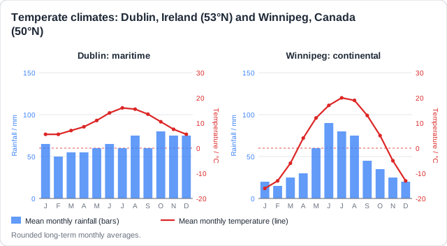
Real example: Dublin, Ireland (53°N), beside the Atlantic, ranges from 5.5°C to 16°C and gets about 780 mm of rain spread over the year: its natural biome is oak woodland. Winnipeg, Canada (50°N), 1,000 km from any ocean, ranges from minus 16°C to 20°C with about 520 mm, most in summer: it lies at the edge of the prairie grassland, with boreal forest further north.
Temperature range, not the average: Dublin and Winnipeg have similar yearly averages. The difference is the range: about 10°C against about 36°C. Quote the range to show maritime or continental.
Feeling unprepared for exams?
Get a clear study plan, practice with real questions, and know exactly where you stand before exam day. No more guessing.
Polar climates are cold all year and surprisingly dry. Only a few plants cope, so polar biomes are simple.
Polar
- Polar: high latitudes: cold all year, with a short, cool summer.
- Why: the sun is low in the sky, so its energy spreads over a large area and passes through more air.
- There are months of darkness in winter, and snow and ice reflect much of the sunlight.
- Cold air sinks, so there is little precipitation: many polar places are cold deserts.
- Biomes: tundra on the land; ice sheets where it never warms above 0°C.
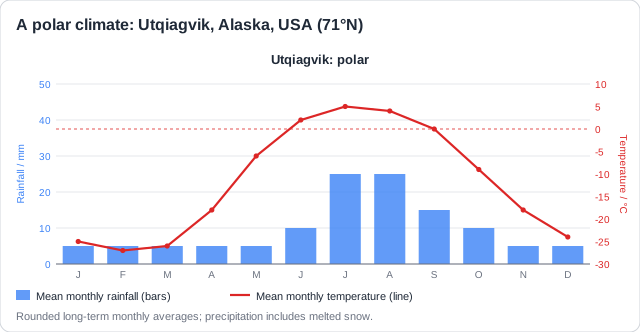
Real example: Utqiagvik, Alaska (71°N), the northernmost town in the USA, has about two months when the sun does not rise. It gets only about 120 mm of precipitation a year, less than many deserts, and the ground beneath the tundra is permafrost, hundreds of metres deep. Further south still, Antarctica is so cold that almost all of it is ice sheet, with no biome of plants at all.
How this comes up: Paper 1 gives a climate map or graphs: identify the climate type [1]. Paper 2 asks you to explain why two places differ [2-4]: name each type, give the reason, then the biome.
Dublin in Ireland (53°N) and Winnipeg in Canada (50°N) lie at similar latitudes. Dublin's temperatures range from 5.5°C to 16°C; Winnipeg's range from minus 16°C to 20°C.
Explain why the two cities have different climates and natural biomes.
Model answer plan
See the mark-by-mark plan — for / against / judgement, with marking guidance — in study mode.