Warmer oceans and stronger cyclones at Higher Level: An HL-only statement. A cyclone runs on warm sea water, and the oceans are warming. You will see why that makes storms fiercer and wetter, read the evidence from real storm records, and judge how strong that evidence is.
Practise this as you read
- Explain why warmer water and air give cyclones more energy.
- Describe the evidence, with numbers, and its limits.
Free preview
This is the free notes preview
You're reading the free notes. Aimnova Pro unlocks the full study experience — and you can try it with your first topic free to keep:
- FlashcardsLock in vocabulary and key terms with spaced repetition.
- Practice questionsAnswer exam-style questions and get instant AI marking.
- Mock exams & past-paper vaultSit full mocks and see exactly how examiners award marks.
- Personalised study planA daily plan built around your exam date and weak areas.
More heat, more energy: A cyclone's fuel is warm, moist air from the ocean. Global warming is heating the oceans, so the fuel tank is getting bigger.
The points to remember
- Global warming is heating the oceans: warmer water and air have more energy.
- Warmer water evaporates faster, so more water vapour feeds the storm.
- When that vapour condenses, it releases more heat, so the air rises faster and the pressure falls lower.
- So cyclones can reach higher wind speeds: more intense storms.
- Warmer seas stay above 26.5 °C for longer each year: a longer cyclone season.
Warmer sea
- The Gulf of Mexico was about 30 °C when Harvey crossed it in August 2017.
More evaporation
- Harvey picked up huge amounts of water vapour from the warm Gulf.
More heat released
- The vapour condensed in its clouds, releasing heat that drove the storm.
Stronger storm
- Harvey grew into a Category 4 hurricane before it reached Texas.
Remember it as: Warmer water, more fuel, fiercer storm.
Know your predicted grade
Take timed mock exams and get detailed feedback on every answer. See exactly where you're losing marks.
A warmer world makes cyclones worse in two more ways: more rain, and a higher sea for the storm to push inland.
Wetter storms, higher surges
- Warmer air holds more water vapour: about 7% more for every 1 °C.
- So cyclones bring heavier rain, and more floods and landslides.
- Global warming also raises the sea level (water expands as it warms; ice melts).
- A higher sea makes every storm surge reach further inland: more coastal flooding.
Real example: in August 2017 Hurricane Harvey stalled over Texas for four days. Up to 1,539 mm of rain fell, the most from any storm in US history, and much of Houston flooded. Scientists estimated that global warming made its rain about 15-38% heavier.
The sea is already higher: Global sea level has risen about 20 cm since 1900, so a storm surge today starts from a higher sea than the same storm would have a century ago.
Faster strengthening: Rapid intensification happens when a storm crosses a very warm, deep layer of sea.
The points to remember
- A very warm sea, warm to a great depth, can make a storm strengthen very fast.
- Some now jump from a tropical storm to a major hurricane in a day or two.
- This gives people less time to prepare or leave.
Real example: on 24 October 2023, Otis was forecast to reach Acapulco, Mexico, as a tropical storm. Over sea at about 30 °C it strengthened into a Category 5 hurricane in about 24 hours and hit the city with winds of about 270 km/h, the strongest ever to reach Mexico's Pacific coast. There was almost no time to warn people, and about 50 died.
Get feedback like a real examiner
Submit your answers and get instant feedback — what you did well, what's missing, and exactly what to write to score full marks.
The guide asks for evidence that hurricanes and typhoons are increasing. Here are the data.
The evidence
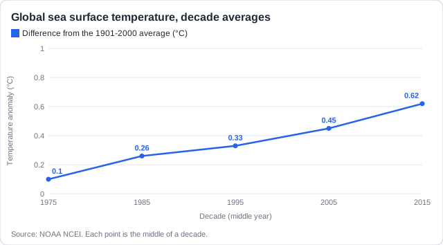
- The oceans have warmed: global sea surface temperature has risen by about 0.5 °C since the 1970s.
- North Atlantic Category 4 and 5 hurricanes: 9 in 1971-80, 25 in 2001-10, 19 in 2011-20.
- Worldwide, the share of storms that reach Category 3 to 5 has likely risen over the last 40 years.
- In the north-west Pacific, typhoons now reach their peak strength further north, nearer Japan and China.
- Rainfall from single storms has broken records (Harvey, 2017).
Now compare the number of the strongest North Atlantic hurricanes in the same five decades.
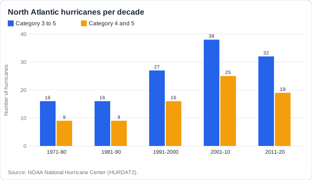
Describing a relationship: Give the trend with numbers ('as the sea warmed from 0.10 to 0.62 °C, Category 4-5 hurricanes rose from 9 to 19 a decade'). Then give the exception ('but they fell from 25 to 19 while the sea kept warming'), or say the link is not clear.
How sure are we?: The link between warmer oceans and stronger cyclones is clear in the physics and in recent data. The evidence has limits, and a good answer says so.
The limits of the evidence
- The total number of cyclones each year has not clearly risen; the rise is in the strongest ones.
- Good records start only with satellites, in the 1970s: older storms at sea were missed or measured badly.
- Natural swings, such as El Niño and La Niña, change the number of storms from year to year.
- One storm is not proof: a strong storm can come in a cool year, and a weak one in a warm year.
- Damage also rises because more people and buildings are on the coast, not only because storms are stronger.
Real example: Hurricane Maria crossed Dominica on 18 September 2017 as a Category 5 storm, the strongest in the island's records. Its damage was worth about 226% of Dominica's GDP. It fits the trend, but on its own it proves nothing: Dominica's next-strongest, Hurricane David, came in 1979, when the sea was cooler.
Name the cause: 'Climate change makes cyclones worse' is too vague. Name the change: higher sea temperatures, or sea level rise, then the effect on the storm.
Learn what examiners really want
See exactly what to write to score full marks. Our AI shows you model answers and the key phrases examiners look for.
How this comes up: Paper 1 case studies of storm-hit islands: describe the relationship between sea temperature and hurricane strength from two graphs [2], or describe how climate change may affect the cyclones in a fact file [2].
Between 1971-80 and 2011-20, global sea surface temperature rose from 0.10 °C to 0.62 °C above the 1901-2000 average. The numbers of Category 4 and 5 hurricanes in the North Atlantic in the five decades were 9, 9, 16, 25 and 19.
Describe the relationship between sea surface temperature and the number of Category 4 and 5 hurricanes.
Model answer plan
See the mark-by-mark plan — for / against / judgement, with marking guidance — in study mode.
The fact-file version: Link each effect to its cause: higher sea temperatures give more intense cyclones and heavier rain; sea level rise gives bigger storm surges.