El Niño and La Niña at Higher Level: An HL-only statement. Every few years the winds over the Pacific weaken or strengthen, and fishing ports in Peru, farms in Ethiopia and forests in Indonesia all feel it. You will follow the change from the winds to the water to the fish and the rain.
Practise this as you read
- Explain how a weaker or stronger Walker circulation changes upwelling off Peru.
- Name effects of El Niño and La Niña in real places, near and far.
Free preview
This is the free notes preview
You're reading the free notes. Aimnova Pro unlocks the full study experience — and you can try it with your first topic free to keep:
- FlashcardsLock in vocabulary and key terms with spaced repetition.
- Practice questionsAnswer exam-style questions and get instant AI marking.
- Mock exams & past-paper vaultSit full mocks and see exactly how examiners award marks.
- Personalised study planA daily plan built around your exam date and weak areas.
The normal Pacific: In a normal year the trade winds drive a loop of air across the Pacific, and they pull cold water up off Peru.
The points to remember
- The trade winds blow from east to west across the tropical Pacific.
- They push warm surface water west, so it piles up near Indonesia and Australia.
- Over this warm water, air rises: clouds form and heavy rain falls (low pressure).
- The air flows east high up and sinks over the cool eastern Pacific: dry weather (high pressure).
- This loop of air is the Walker circulation.
- Off Peru, winds push surface water away, so cold, nutrient-rich water rises (upwelling): very productive seas.
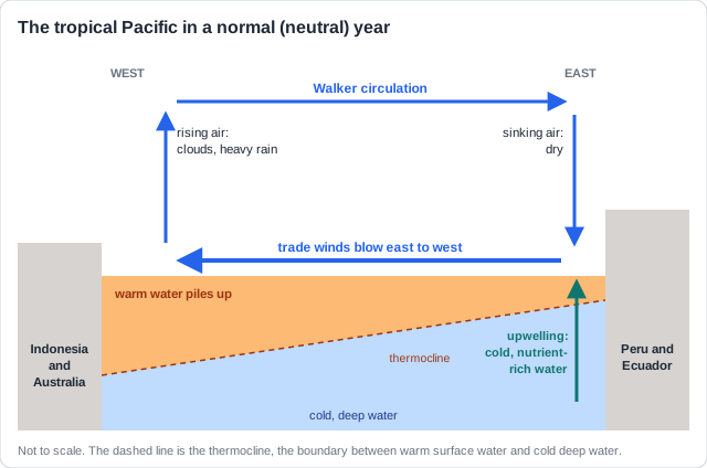
Remember it as: Wet west, dry east, and a cold, fishy sea off Peru.
Real example: Jakarta, in Indonesia, gets about 1,800 mm of rain a year. Lima, on the coast of Peru, also in the tropics, gets under 20 mm: it sits under the sinking, dry air. Yet the sea off Lima is one of the richest on Earth: upwelling feeds the plankton that feed the anchoveta.
See how examiners mark answers
Answer exam-style questions with model answers. Learn exactly what earns marks and what doesn't.
How an El Niño develops: El Niño starts when the trade winds weaken or reverse. The Walker circulation weakens, and the warm water they held in the west spreads back east.
The points to remember
- The trade winds weaken, or even reverse: the Walker circulation weakens or reverses.
- Warm water that was piled up in the west flows back east across the Pacific.
- A thick warm layer now sits on top of the cold water off South America: the surface is stratified.
- Warm water is lighter, so the layers do not mix: upwelling of cold, nutrient-rich water decreases.
- Rising air and heavy rain move east, to the central Pacific and the coast of Peru and Ecuador.
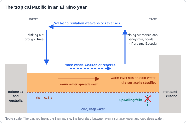
Why the layers do not mix: Warm water is less dense than cold water, so it floats on top. A thick warm layer is a lid: the surface is stratified, and the cold, nutrient-rich water below cannot rise.
Real example: in 2015 the trade winds weakened through the year. By November the central Pacific was about 2.6 °C warmer than normal, making the 2015-16 El Niño one of the three strongest since 1950 (with 1982-83 and 1997-98). How often El Niño comes, and why it is hard to predict, is on 2.4.10.
The direct effects hit the sea and coast of Peru and Ecuador first.
Peru's sea and coast in an El Niño
- Less upwelling means fewer nutrients at the surface, so phytoplankton (plankton) growth falls.
- The food chain above it collapses: fish such as the anchoveta die or move away.
- Seabirds and sea lions that eat them starve; the fishing industry loses its catch.
- Warmer water bleaches corals in the eastern Pacific.
- On land, the normally dry coast of Peru and Ecuador gets heavy rain, floods and landslides.
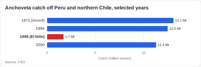
Real example: in the 1997-98 El Niño, the sea off northern Peru was 3.7 °C warmer than normal in December 1997. Plankton growth fell, and the anchoveta catch dropped from 12.5 million tonnes (1994) to 1.7 million tonnes (1998). Fishmeal prices rose around the world. On land, rain fell on the Sechura Desert of northern Peru, and a lake formed where there had been dry sand.
Corals too: In the 1982-83 El Niño, warm water killed about 95% of the corals around the Galápagos Islands, off Ecuador.
Study smarter, not longer
Most students waste 40% of study time on topics they already know. Our AI tracks your progress and optimizes every minute.
Effects far away: El Niño moves where air rises (rain) and sinks (drought). So it changes the weather indirectly across the tropics and subtropics.
The points to remember
- El Niño changes the weather far away indirectly, by moving where air rises and sinks.
- Drought where rain normally falls: Indonesia, eastern Australia, southern Africa, India's monsoon.
- Drought brings forest fires, crop failure and food shortages.
- More rain in other places: the coast of Peru and Ecuador, the southern USA.
- Warm seas bleach coral reefs, and global temperatures rise for a year or so.
- Fewer Atlantic hurricanes, more in the central and eastern Pacific.
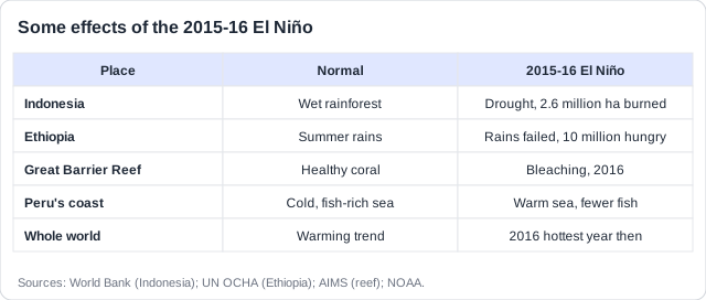
Real example: during the 2015-16 El Niño, drought in Indonesia let fires spread through dried-out forest and peat, burning 2.6 million hectares and covering South-East Asia in smoke. In Ethiopia the rains failed and about 10 million people needed food aid.
Name the place, then the change: Write 'drought in Indonesia, so forest fires', not 'droughts in some places'. Each effect needs a named place and what happened there.
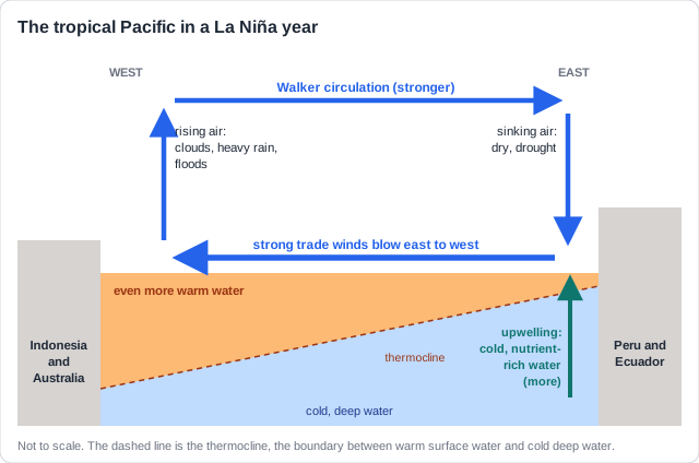
La Niña: the opposite: La Niña is due to a strengthening of the Walker circulation: stronger trade winds, colder water off South America, and the other effects of El Niño reversed.
The points to remember
- The trade winds strengthen: the Walker circulation gets stronger than normal.
- Even more warm water piles up in the west; the eastern Pacific gets colder.
- More upwelling off Peru: more nutrients, more plankton, bigger fish catches.
- Heavier rain and floods in Indonesia and eastern Australia.
- Drought on the coast of Peru and Ecuador, in the southern USA and in East Africa.
- More Atlantic hurricanes. The other effects of El Niño are reversed.
| El Niño | La Niña | |
|---|---|---|
| Walker circulation | Weakens or reverses | Strengthens |
| Upwelling off Peru | Decreases | Increases |
| Fish catch off Peru | Falls | Rises |
| Indonesia, Australia | Drought, fires | Heavy rain, floods |
| Coast of Peru | Heavy rain, floods | Drought |
| Atlantic hurricanes | Fewer | More |
Real example: the strong La Niña of 2010-11 brought Australia its wettest spring on record; in January 2011 floods covered much of Queensland and reached Brisbane. A long La Niña from 2020 to 2023 brought five failed rainy seasons in a row to the Horn of Africa, and the 2020 Atlantic season had a record 30 named storms.
Practice with exam-style questions
Answer exam-style questions and get AI feedback that shows you exactly what examiners want to see in a full-marks response.
How this comes up: Paper 2: explain how a change in the winds changes the sea, with data on sea temperature or fish catches. Paper 1: a case study of a fishing coast or a drought, with El Niño in its fact file.
In late 2023 the trade winds over the Pacific weakened, the sea off Peru warmed by more than 2 °C, and the government cancelled the first anchoveta fishing season of the year.
Explain how a weakening of the Walker circulation can reduce the fish catch off Peru.
Model answer plan
See the mark-by-mark plan — for / against / judgement, with marking guidance — in study mode.
The La Niña version: Turn every step round: stronger trade winds, more upwelling, more nutrients, more plankton, a bigger catch.