The ENSO cycle at Higher Level: An HL-only page. Every few years the vast tropical Pacific warms or cools by a degree or two, and the winds across it change. This swing, the El Niño Southern Oscillation, never keeps a steady beat.
Practise this as you read
- Outline the ENSO cycle and its states.
- Explain why El Niño and La Niña events are hard to predict.
Free preview
This is the free notes preview
You're reading the free notes. Aimnova Pro unlocks the full study experience — and you can try it with your first topic free to keep:
- FlashcardsLock in vocabulary and key terms with spaced repetition.
- Practice questionsAnswer exam-style questions and get instant AI marking.
- Mock exams & past-paper vaultSit full mocks and see exactly how examiners award marks.
- Personalised study planA daily plan built around your exam date and weak areas.
A see-saw across the Pacific: The ENSO cycle is the rise and fall of the trade winds and the sea surface temperature that shapes conditions in the tropical Pacific Ocean. It never settles: it keeps swinging between two opposite extremes.
The points to remember
- ENSO = El Niño Southern Oscillation.
- It is a cycle of change in the tropical Pacific Ocean.
- Two things swing together: the wind (the trade winds) and the sea surface temperature.
- The ocean and the air affect each other: warmer sea weakens the winds, weaker winds warm the sea more.
- The Southern Oscillation is the air-pressure see-saw between the east and west Pacific.
Remember it as: ENSO: the wind and the warm water swing together.
Real example: the swing shows up in air pressure. Since 1876 scientists have compared the pressure at Tahiti, in the middle of the Pacific, with the pressure at Darwin, Australia, in the west. When one rises the other falls: this see-saw, the Southern Oscillation Index, is still used to track ENSO today.
Coming next: Why the winds weaken or strengthen (the Walker circulation) and what El Niño and La Niña do to weather and fisheries are on the next page, 2.4.11.
Get feedback like a real examiner
Submit your answers and get instant feedback — what you did well, what's missing, and exactly what to write to score full marks.
The cycle has two opposite, extreme states, El Niño and La Niña. Most of the time the Pacific is somewhere in between.
The states of the cycle
- El Niño: one extreme: central and eastern Pacific warmer than average; trade winds weaker.
- La Niña: the opposite extreme: cooler than average; trade winds stronger.
- Neutral: temperatures and winds close to average.
- Transitional: the states in between, as conditions move from one to another.
- Measured as the difference from average sea temperature: above +0.5°C El Niño, below -0.5°C La Niña.
El Niño (warm extreme)
- Central and eastern Pacific warmer than average
- Trade winds weaker, or even reversed
- Above +0.5°C for several months
- Example: 2015-16, +2.6°C
La Niña (cool extreme)
- Central and eastern Pacific cooler than average
- Trade winds stronger than usual
- Below -0.5°C for several months
- Example: 2020-21, -1.3°C
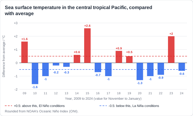
Real example: in 2012 and 2013 the Pacific stayed within half a degree of average: neutral. In late 2019 it touched +0.5°C for only a few weeks and then cooled again: a transitional state that never became a full El Niño.
If ENSO were a regular clock, farmers and fishing fleets could plan years ahead. It is not.
Irregular and hard to predict
- Frequency is irregular: El Niño comes about every 2 to 7 years, with no fixed rhythm.
- Length varies: most events last about a year, but La Niña can last two or three years.
- Intensity is irregular: some events are weak, others very strong.
- So both are hard to predict: forecasts more than a few months ahead are uncertain.
- Why: ocean and air feed back on each other, so small changes can grow or fade.
2014
- Forecasters expected a strong El Niño. The Pacific warmed a little, then stalled: it stayed weak.
2015-16
- A year later, with less warning, came one of the strongest El Niños on record, +2.6°C.
2018-19
- The next El Niño was weak, only about +0.9°C, and short.
2020-23
- La Niña returned three winters in a row, a rare 'triple dip', before a strong El Niño in 2023.
Not every few years like clockwork: Avoid 'El Niño happens every 4 years'. Say it recurs irregularly, roughly every 2 to 7 years, and varies in strength.
Learn what examiners really want
See exactly what to write to score full marks. Our AI shows you model answers and the key phrases examiners look for.
How this comes up: Paper 2 gives a graph of Pacific sea temperatures: identify a state [1], then outline or explain features of the cycle [2-4]. Use the graph's years and values in every point.
Between late 2020 and early 2023 the tropical Pacific had La Niña conditions three winters in a row. In 2023 a strong El Niño followed, with sea temperatures about 2°C above average.
Outline three features of the ENSO cycle shown by these events.
Model answer plan
See the mark-by-mark plan — for / against / judgement, with marking guidance — in study mode.