Classifying soils at Higher Level: This statement is Higher Level only. It shows how soils are named and mapped from their whole profile, how to draw a profile diagram, and how four soils match four biomes: podzol, brown earth, chernozem and oxisol.
Practise this as you read
- Classify a profile and link it to its biome.
- Draw a labelled profile diagram to scale.
Free preview
This is the free notes preview
You're reading the free notes. Aimnova Pro unlocks the full study experience — and you can try it with your first topic free to keep:
- FlashcardsLock in vocabulary and key terms with spaced repetition.
- Practice questionsAnswer exam-style questions and get instant AI marking.
- Mock exams & past-paper vaultSit full mocks and see exactly how examiners award marks.
- Personalised study planA daily plan built around your exam date and weak areas.
A soil is named from its whole profile: Dig a pit and look at the wall: you see the soil profile, made of horizons. Soil scientists name a soil from the whole profile, then map where that type is found in a soil survey.
The points to remember
- Soil scientists classify a soil by the appearance of its whole profile, not by one layer.
- They record each horizon: its depth, colour, texture, organic matter, stones and pH.
- Soils with the same set of horizons are the same soil type, wherever they are.
- A soil map shows where each soil type is found, so farmers and planners know what the land can do.
- Each type is formed by the same processes, so the profile tells the story of how the soil formed.
Remember it as: Read the whole wall, not one layer.
| What is recorded | How | What it tells you |
|---|---|---|
| Depth of each horizon | a tape measure down the pit wall | how deep the soil has developed |
| Colour | matched to a standard colour chart | humus (dark), iron (red), waterlogging (grey) |
| Texture | rubbed between the fingers | how much sand, silt and clay |
| pH | a test kit or meter | how acid or alkaline: which plants can grow |
Real example: the United States has mapped the soils of almost the whole country. Any farmer can open the free Web Soil Survey, find their field and read which soil type it is. Worldwide, the FAO system sorts soils into 32 main groups by their profiles.
Get feedback like a real examiner
Submit your answers and get instant feedback — what you did well, what's missing, and exactly what to write to score full marks.
A profile diagram is how you describe a soil on paper. It also explains it: each layer is the result of a process, such as eluviation out of one layer and illuviation into the one below.
How to draw a profile diagram
- Draw a column to scale, with a depth scale in cm down the side.
- Draw a line at each boundary: sharp or gradual, straight or wavy.
- Label each horizon (O, A, E, B, C) and describe its colour, texture and contents.
- Add arrows for the processes: leaching down, mixing by earthworms, iron washed into B.
- The diagram then explains the soil: which transfers and transformations made each layer.
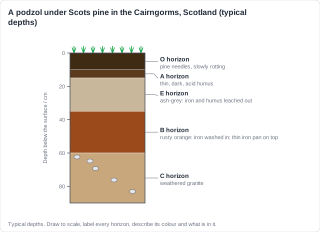
O
Pine needles rot slowly in the cold, making acid humus.
A and E
Acid rainwater carries iron and humus down out of the E horizon, leaving it ash-grey.
B
The iron is deposited here, turning B rusty and sometimes forming a hard iron pan.
C
Below, granite slowly weathers into the parent material.
Real example: this is the soil under the old Scots pine forests of the Cairngorms in Scotland. Its pale E horizon shows at a glance that rain has leached it for thousands of years.
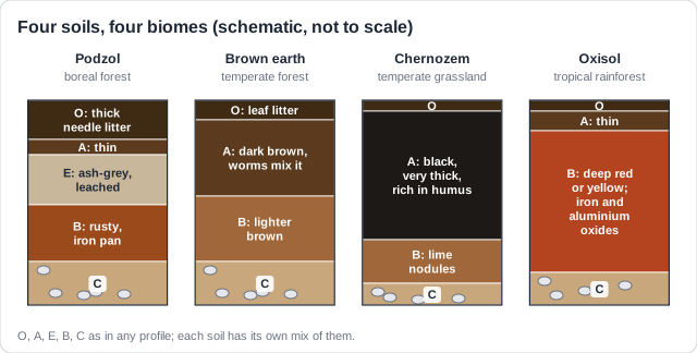
Each biome builds its own kind of profile, because climate and vegetation control the processes. Learn four soils, one for each biome you study.
Four soils, four biomes
- Podzol (boreal forest): thick needle litter, a pale grey E horizon, a rusty B, often an iron pan.
- Brown earth (temperate deciduous forest): deep dark brown A, earthworms mix it, gradual boundaries.
- Chernozem (temperate grassland): a very thick black A full of humus; lime nodules in the B.
- Oxisol (tropical rainforest): thin O and A, a deep red or yellow B of iron and aluminium oxides.
- Each profile matches its biome's climate and vegetation: cold and acid, mild, dry grassland, hot and wet.
| Soil | Biome and climate | Why it looks like this | Real places |
|---|---|---|---|
| Podzol | boreal forest: cold, wet | acid needles rot slowly; heavy leaching makes the E | Finland, Siberia, Canada |
| Brown earth | temperate deciduous: mild | rich leaf litter; earthworms mix it; mild leaching | England, Germany |
| Chernozem | temperate grassland: dry summers | grass roots die each year; little leaching | Ukraine, Russian steppe, US prairies |
| Oxisol | rainforest: hot, very wet | fast decay and deep weathering; heavy leaching | Amazon and Congo basins |
Rich forest, poor soil: An oxisol is not fertile, even under the richest forest on Earth. Leaves rot within weeks and the nutrients go straight back into the trees, so most nutrients are held in the plants, not the soil. Clear the forest and the soil is soon exhausted.
Learn what examiners really want
See exactly what to write to score full marks. Our AI shows you model answers and the key phrases examiners look for.
Classifying an unknown profile works like a key: look for the one feature that gives each soil away, then link it to the biome.
Classify it in four questions
- Is there a pale, ash-grey layer under the topsoil? Then it is strongly leached: a podzol.
- Is the topsoil black and deeper than about 40 cm? A grassland soil: a chernozem.
- Is the soil deep red or yellow with almost no topsoil? Hot, wet weathering: an oxisol.
- Dark brown topsoil merging gently into brown subsoil, with earthworms? A brown earth.
- Then name the biome and give one feature that shows how it formed.
Remember it as: Grey layer: podzol. Black and deep: chernozem. Red and deep: oxisol. Brown and mixed: brown earth.
Look
- A thin layer of leaves on the surface, then only 10 cm of darker topsoil
Below
- Red and yellow soil that goes on down for several metres, with no pale grey layer
Classify
- Deep red, almost no topsoil, no E horizon: an oxisol
Biome
- Tropical rainforest: hot, wet all year, so rock weathers deeply and leaves rot fast
Give the evidence: Naming the soil is only the start. Say which feature you used (the black A, the grey E) and what process made it: that is the link to the biome.
How this comes up: Paper 2, Section A: two profile diagrams to classify and explain, or a profile to draw. Section B (a): outline how profiles are used to classify soils, with named biomes.
A soil pit dug under Scots pine in northern Finland shows thick needle litter, a thin dark layer, an ash-grey layer 20 cm thick and a rusty orange layer below it.
Explain how the climate and vegetation of this biome produce the ash-grey layer.
Model answer plan
See the mark-by-mark plan — for / against / judgement, with marking guidance — in study mode.