Deciding what goes where: Urban planning is how a city chooses where homes, shops, factories, parks and roads go.
The points to remember
- Urban planning decides the best way to use land and buildings in a city.
- It zones land: what may be built where (homes, shops, factories, parks).
- It plans transport, services (water, sewers, schools, hospitals) and green space.
- It looks ahead: where new homes and jobs will go as the city grows.
- Plans are made by governments, with developers, businesses and residents.
Remember it as: Where, what, for whom: the planner's three questions.
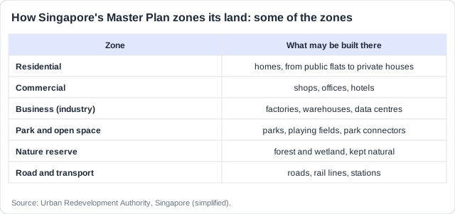
Real example: Singapore fits about 6 million people on about 735 km². Its planning authority writes a Concept Plan for the next 40-50 years and a Master Plan, reviewed every five years, which zones every plot of land.
Free preview
This is the free notes preview
You're reading the free notes. Aimnova Pro unlocks the full study experience — and you can try it with your first topic free to keep:
- FlashcardsLock in vocabulary and key terms with spaced repetition.
- Practice questionsAnswer exam-style questions and get instant AI marking.
- Mock exams & past-paper vaultSit full mocks and see exactly how examiners award marks.
- Personalised study planA daily plan built around your exam date and weak areas.
Planners divide a city into zones. Each zone has its own job, and its own look on a map.
The main land use zones
- CBD (central business district): offices, shops, services; highest land values, tallest buildings, easiest to reach.
- Industrial: factories and warehouses near ports, railways, motorways, away from homes.
- Residential: from high-density flats near the centre to low-density suburbs.
- Green space: parks, gardens, nature reserves, urban forests, for wellbeing and ecosystem services.
- Transport land (roads, railways, ports, airports) and mixed use (homes above shops).
Reading zones on a map or a satellite image: Tall buildings packed together: the CBD. Regular rows of houses: residential. Large buildings with yards beside a railway or port: industrial. Green patches: parks.
Real example: in Singapore, factories are grouped in industrial estates such as Jurong, in the west, close to the port, while housing estates are planned around railway stations.
Stop wasting time on topics you know
Our AI identifies your weak areas and focuses your study time where it matters. No more overstudying easy topics.
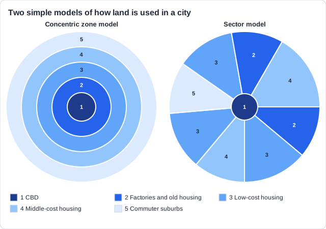
Geographers drew simple models to show how land use is arranged in a city. No real city matches one exactly, but they help you describe a map.
Three models of a city
- Concentric zone model (Burgess): the CBD in the centre, rings of land use around it.
- Sector model (Hoyt): land uses spread out in wedges along transport routes.
- Multiple nuclei model (Harris and Ullman): several centres of activity, not one CBD.
- Reality: most cities mix these patterns, shaped by history, relief, rivers and planning.
Real example: Singapore has several centres: as well as its CBD, the Master Plan grows regional centres such as Jurong East and Tampines, closer to where people live: a multiple nuclei pattern.
A good plan meets the needs of everyone in the community, the stakeholders.
The needs a plan must meet
- Physical: safe buildings, roads, water, sewers and power.
- Domestic: enough affordable homes, with schools and shops nearby.
- Environmental: clean air and water, green space, protected habitats.
- Commercial and industrial: land, transport links and workers for businesses.
- Financial: a plan the city can afford that brings jobs and taxes.
- Health: clean air, hospitals, space to exercise, no overcrowding.
Residents
- Homes they can afford
- Schools, clinics, parks
Businesses and industry
- Land and transport links
- Workers nearby
Government and groups
- A plan it can pay for
- Clean air, protected habitats
Real example: each of Singapore's public housing towns is planned with a town centre of shops, schools, a clinic and a railway station, so residents' domestic and health needs are met close to home.
See how examiners mark answers
Answer exam-style questions with model answers. Learn exactly what earns marks and what doesn't.
Needs often clash. Planning is about weighing them, and someone usually loses out.
When needs clash
- Stakeholders want different things: new homes or open countryside, roads or quiet streets.
- Planners weigh the needs and look for a compromise.
- Consultation: residents can comment on a plan before it is approved.
- A plan that meets one group's needs can leave others out.
What a plan can protect
- Farmland and countryside
- Clean air and quiet
- Habitats and parks
What it can cost
- Fewer new homes
- Higher land prices
- Longer journeys for some
Real example: London's green belt, set up from 1938, protects a ring of countryside around the city from building. It keeps open space for people and wildlife, but limits the land for new homes, which helps push up house prices.
Name the stakeholder and the need: Write 'farmers need the green belt to keep their land; families need new homes', not 'people disagree'.
How this can come up: Paper 2, Section B (a): outline four needs [4], with a named city.
Singapore plans every plot of its land through a Master Plan, reviewed every five years.
With reference to a named city, outline four needs of the community that urban planning aims to meet.
Model answer plan
See the mark-by-mark plan — for / against / judgement, with marking guidance — in study mode.