Layers from the surface to the rock: Dig a pit and look at its wall: the soil is in layers. The whole set of layers is the soil profile; each layer is a horizon.
The points to remember
- A soil profile is the soil seen from the surface down to the rock, as in the wall of a pit.
- It is made of layers called horizons, each with its own colour, texture and make-up.
- Organic at the top: dead leaves and dark humus.
- Inorganic below: paler mineral soil, then broken rock, then solid rock.
- The layers are stable: once formed, they keep their order for a long time.
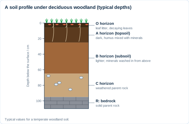
Read it from the top down: Colour is the clue: dark means humus, pale or orange means mineral soil, stones mean the parent rock is near.
Real example: under the Amazon rainforest, the dark topsoil is often only a few centimetres thick, above metres of red, nutrient-poor subsoil. Heavy rain leaches it, so most nutrients are stored in the trees, not the soil.
Free preview
This is the free notes preview
You're reading the free notes. Aimnova Pro unlocks the full study experience — and you can try it with your first topic free to keep:
- FlashcardsLock in vocabulary and key terms with spaced repetition.
- Practice questionsAnswer exam-style questions and get instant AI marking.
- Mock exams & past-paper vaultSit full mocks and see exactly how examiners award marks.
- Personalised study planA daily plan built around your exam date and weak areas.
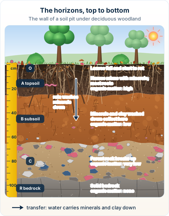
Soil scientists label the horizons with letters, from the top down. Learn them in order: O, A, B, C, R.
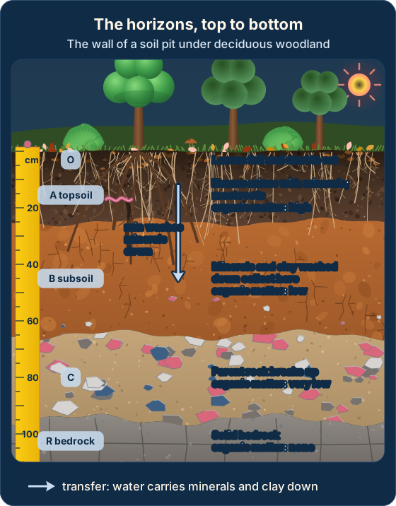
The horizons, top to bottom
- O: fallen leaves and other dead matter, rotting on the surface.
- A (topsoil): dark, humus mixed with minerals; most roots and soil life.
- B (subsoil): lighter; minerals and clay washed down from above build up here.
- C: broken, weathered pieces of the parent rock; little organic matter.
- R: the solid parent rock (bedrock) underneath.
- The A horizon matters most for plant growth, and it is the easiest to lose.
Remember it as: O on top, A for the roots, B below, C is broken rock, R is solid rock.
| Horizon | Colour | Organic matter | What happens there |
|---|---|---|---|
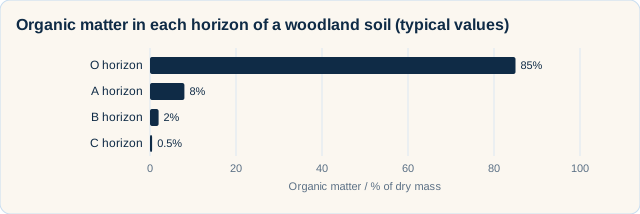
| O | Brown to black | Very high | Leaves fall and start to rot |
| A (topsoil) | Dark brown | High | Humus mixes with minerals; most roots |
| B (subsoil) | Lighter, often orange | Low | Minerals and clay washed down collect |
| C | Pale, stony | Very low | Parent rock breaks up |
| R | Rock colour | None | Solid bedrock |
Real example: in England, a government code of practice tells builders to strip the topsoil off a site and store it in its own heap, so it can be spread back on top of gardens and parks later.
Know your predicted grade
Take timed mock exams and get detailed feedback on every answer. See exactly where you're losing marks.
Made by the soil system itself: The horizons form from interactions inside the soil: dead matter added at the top, water carrying minerals down, animals mixing, rock breaking up at the bottom. It takes hundreds to thousands of years.
How the layers form
- Dead leaves fall and decay at the top: humification makes humus.
- Earthworms and other animals mix humus into the top mineral layer.
- Rainwater soaking down leaches dissolved minerals out of the upper layers.
- Fine clay is washed down too (eluviation) and builds up lower down (illuviation).
- At the base, weathering keeps breaking the parent rock into fragments.
- It is slow: about 1 cm of soil every 100 to 1,000 years, so lost soil is not replaced in a lifetime.
- Humification
- dead matter being broken down into humus.
- Leaching
- water carrying dissolved minerals down through the soil.
- Eluviation
- fine particles such as clay being washed out of an upper layer.
- Illuviation
- those particles being laid down in a lower layer, usually the B horizon.
Real example: most of Scotland was covered by ice until about 11,500 years ago, which scraped the old soil away. Its soils have all formed since then, and many are still less than a metre deep.
Renewable, but not in a lifetime: Soil does form again, but at about 1 cm per 100 to 1,000 years. Topsoil lost to erosion in a few years cannot be replaced in a human lifetime, so treat it as non-renewable.
You can compare two soils yourself. Dig to the B horizon at two sites, one managed by people and one natural, and run the same tests on both samples.
What to test
- Take both samples from the B horizon: one from a garden or field, one from a natural ecosystem.
- Texture: rub it between your fingers, or shake it in a jar of water and let the layers settle.
- Nutrients: a test kit for nitrogen (N), phosphorus (P) and potassium (K).
- Drainage: time how fast water poured on the soil drains through.
- Water retention: weigh the soil wet, dry it, weigh it again.
- Organic matter: dry it, weigh it, burn it, weigh it again: the loss on ignition.
Organic matter by loss on ignition: % organic matter = (mass lost on burning ÷ dry mass) × 100
How to do it
- Dry the soil in an oven until its mass stops changing, then weigh it.
- Heat it strongly in a crucible until the organic matter has burned off.
- Weigh it again: the mass lost is the organic matter that burned.
- Divide by the dry mass, multiply by 100, and write the % sign.
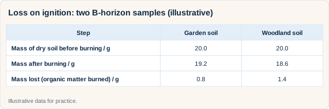
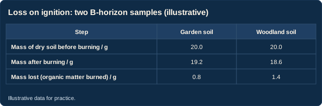
Worked example: Garden soil: mass lost = 20.0 - 19.2 = 0.8 g. % organic matter = (0.8 ÷ 20.0) × 100 = 4.0%.
Check it: the woodland sample gives (1.4 ÷ 20.0) × 100 = 7.0%, more than the garden, because leaf litter in a wood is never cleared away.
Make it a fair test: Same horizon, same mass, both dried until the mass stops changing. Drying first matters: otherwise the mass lost on burning would include water, not just organic matter.
Get feedback like a real examiner
Submit your answers and get instant feedback — what you did well, what's missing, and exactly what to write to score full marks.
How this comes up: Paper 2, Section A: a drawn soil profile with lettered horizons, then short parts.
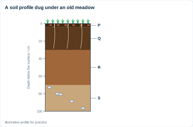
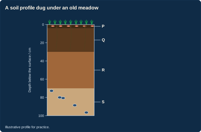
Figure 1 shows a soil profile dug under an old meadow in Wales.
(a) Identify horizon Q.
(b) Describe how the organic content of the soil changes from horizon P to horizon S.
(c) Outline one reason why horizon R is lighter in colour than horizon Q.
Model answer plan
See the answer broken into clear points, with guidance on how each point earns marks.