Uneven heating at Higher Level: The same heating and the same three cells as SL, with different real cases: Darwin and Mawson Station, Phoenix's cool streets, the doldrums and Typhoon Hagibis. At HL, follow the heat all the way: from where the Sun delivers it to where the air gives it up to space.
Practise this as you read
- Draw the three cells with the right arrows, from memory.
- Trace one parcel of heat from the equator to the pole.
Free preview
This is the free notes preview
You're reading the free notes. Aimnova Pro unlocks the full study experience — and you can try it with your first topic free to keep:
- FlashcardsLock in vocabulary and key terms with spaced repetition.
- Practice questionsAnswer exam-style questions and get instant AI marking.
- Mock exams & past-paper vaultSit full mocks and see exactly how examiners award marks.
- Personalised study planA daily plan built around your exam date and weak areas.
The Sun heats the Earth unevenly: The Earth is a ball, so sunlight hits it straight on at the equator but at a slant near the poles. This uneven, or differential, heating is what sets the air moving.
The points to remember
- Differential heating: the Sun heats the Earth unevenly, most at the equator, least at the poles.
- At the equator the Sun is high: its energy falls on a small area, so the ground gets hot.
- Near the poles the same energy arrives at a low angle and spreads over a large area.
- The low-angle rays also pass through more air, which absorbs and scatters some of the energy.
- So the tropics gain more energy than they lose; the poles lose more than they gain.
Remember it as: Straight on: hot. Slanting: spread thin, cold.
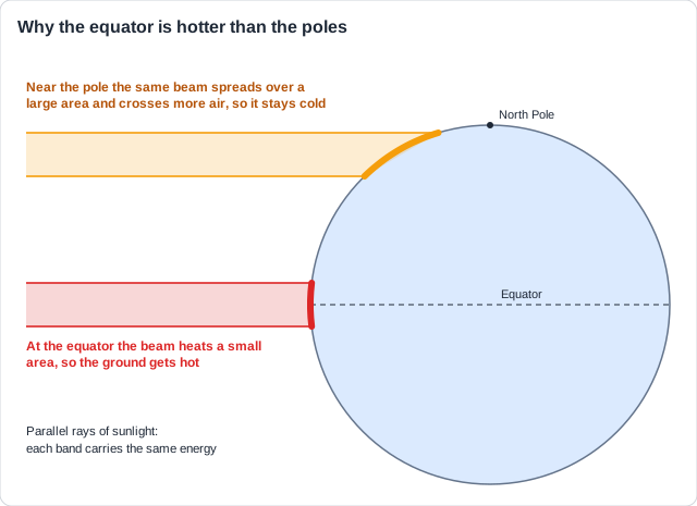
Real example: Darwin, Australia, 12° south of the equator, averages about 28 °C. Mawson Station in Antarctica, at 67° south, averages about -11 °C, even though it gets 24 hours of daylight in midsummer: the Sun stays low, so its energy is spread thin.
See how examiners mark answers
Answer exam-style questions with model answers. Learn exactly what earns marks and what doesn't.
How much of the arriving sunlight a surface keeps also changes from place to place. A surface's albedo adds to the difference between the equator and the poles.
Albedo: how much is reflected
- Albedo is the share of incoming sunlight a surface reflects: 0 to 1, or 0 to 100%.
- Light surfaces reflect a lot: fresh snow 80 to 90%, thick cloud 60 to 90%, sea ice 50 to 70%.
- Dark surfaces absorb most: open ocean about 6%, forest 10 to 20%, asphalt about 4%.
- Snow and ice near the poles reflect much of the little sunlight they get: one more reason the poles stay cold.
- Albedo = light reflected ÷ light arriving. Snow reflecting 85 of 100 units: 0.85, or 85%.
High albedo: reflects
- Fresh snow 0.8 to 0.9
- Thick cloud 0.6 to 0.9
- Sea ice 0.5 to 0.7
- Desert sand 0.3 to 0.4
Low albedo: absorbs
- Open ocean about 0.06
- Dark soil about 0.1
- Forest 0.1 to 0.2
- Asphalt about 0.04
Real example: in Phoenix, Arizona, dark asphalt roads and car parks absorb about 95% of the sunlight and can pass 70 °C on a summer afternoon. Since 2020 the city has painted many streets with a light grey coating that reflects more, and these streets are several degrees cooler.
When the surface changes: Melting ice turns a bright surface into dark sea, which absorbs more, warms, and melts more ice: a positive feedback loop. Warmer seas also make more cloud, which reflects more sunlight: a negative feedback loop. Name the loop and its direction.
Hot air rises: three cells: The hot tropics heat the air above them. It rises, spreads towards the poles and sinks again, turning in great loops called cells. Each half of the Earth has three: the tricellular model.
The three cells
- Warm air is lighter, so it rises (convection); cool air is heavier and sinks.
- Hadley cell (0-30°): air rises at the equator, flows poleward high up, sinks at about 30°.
- Ferrel cell (30-60°): turns the other way: sinks at 30°, flows poleward at the surface, rises at 60°.
- Polar cell (60-90°): cold air sinks at the pole, flows towards 60° at the surface, rises there.
- Rising air means low pressure and rain; sinking air means high pressure and dry weather.
- To draw it: three loops each side of the equator, arrows up at 0° and 60°, down at 30° and the pole.
Remember it as: Up at 0 and 60, down at 30 and 90.
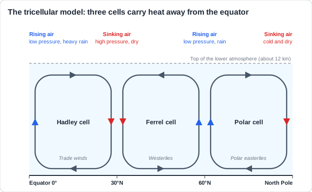
Real example: sailors called the calm belt along the equator the doldrums. There the air rises instead of blowing sideways, so the winds are light, and old sailing ships could drift for days under towering rain clouds.
Study smarter, not longer
Most students waste 40% of study time on topics they already know. Our AI tracks your progress and optimizes every minute.
If heat were not moved, the tropics would get hotter every year and the poles colder. The atmosphere, helped by the oceans, carries the extra heat from the equator towards the poles.
How the heat is moved
- The cells carry warm air away from the equator and bring cooler air back at the surface.
- Latent heat: water evaporating in the tropics takes in heat; when it condenses further away, it releases it.
- Tropical cyclones (hurricanes, typhoons) carry huge amounts of heat towards higher latitudes.
- Winds also drive ocean currents, which carry warm water towards the poles.
- Result: the equator is cooler and high latitudes warmer than they would otherwise be.
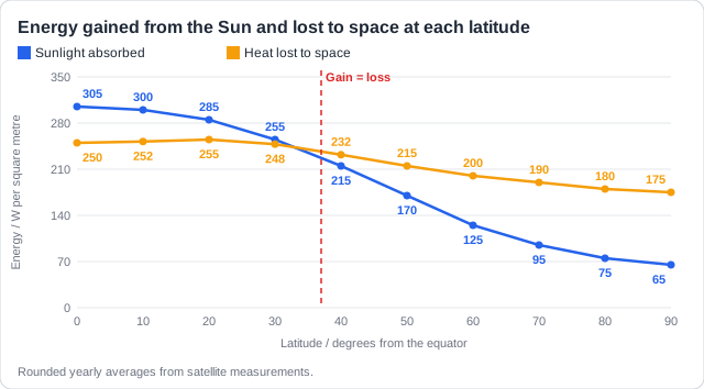
Real example: in October 2019 Typhoon Hagibis formed over the warm tropical Pacific, near the Marshall Islands, and carried its heat and moisture to Tokyo, at 35° north, where it dropped about a metre of rain in two days on some mountains nearby.
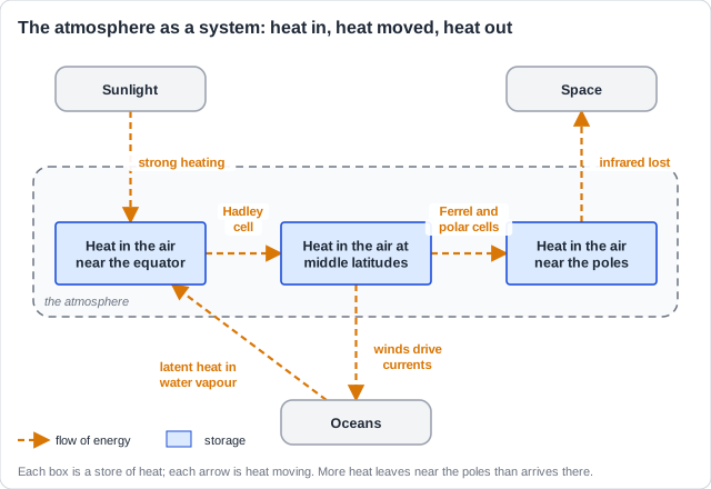
Draw it as a system: Stores of heat go in boxes, flows of heat are arrows. Label each arrow with how the heat moves: the Hadley cell, latent heat, ocean currents.
How this comes up: Paper 2, Section B (b): explain the whole chain, from uneven heating to heat reaching the poles, one point per mark.
Satellites show that the tropics absorb more energy from the Sun than they lose to space, while the polar regions lose more than they absorb, yet neither gets hotter or colder every year.
Explain how differential heating creates the tricellular model and how this circulation redistributes heat.
Model answer plan
See the mark-by-mark plan — for / against / judgement, with marking guidance — in study mode.